Part Two: GIS surface analysis in archaeology
Part Four: Results and discussion
Part One: Iron Age Gower
The area included in this study covers approximately 150 square km and contains thirty-three Iron Age hillforts and defended enclosures. Nine sites are classed as defensive by the National Monuments Record of Wales (NMRW) with the remainder serving a dual defensive and domestic purpose. The distribution of these sites is shown in figure 1:
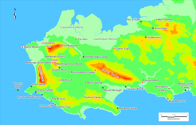
Figure 1: Gower hillforts and other sites
© Base mapping Crown Copyright/database right 2012 (An Ordnance Survey/EDINA supplied service)
| Name | Alternative Name | Type | OSNGR |
| Hardings Down East | Hillfort | SS437906 | |
| Hardings Down Lower | Hardings Down North | Hillfort | SS436908 |
| Hardings Down West | Hillfort | SS434907 | |
| Hen Gastell | Dan y Lan Camp | Hillfort | SS554957 |
| High Pennard | Promontory Fort | SS567866 | |
| Horse Cliff | Promontory Fort | SS434860 | |
| Lewes Castle | Promontory Fort | SS414873 | |
| Llandewi | Hillfort | SS455887 | |
| Maiden Castle | Main Castle | Defended Enclosure | SS509854 |
| Mount Brough | Penrice Castle | Defended Enclosure | SS492878 |
| North Hill Tor | Nottle Tor Camp | Promontory Fort | SS453938 |
| Norton Camp | Promontory Fort | SS491867 | |
| Old Castle | Promontory Fort | SS409879 | |
| Pennard Hill | Hillfort | SS538885 | |
| Pen-y-Gaer | Hillfort | SS536955 | |
| Redley Cliff Camp | Caswell Cliff Camp | Promontory Fort | SS588875 |
| Reynoldston Camp | Hillfort | SS483899 | |
| Stembridge Camp | Promontory Fort | SS469914 | |
| The Bulwark | Hillfort | SS443927 | |
| The Knave | Promontory Fort | SS422871 | |
| Thurba Head Camp | Pitton Camp | Promontory Fort | SS421870 |
| Tor-Gro | Hillfort | SS461935 | |
| Un-named | Enclosure | SS541937 | |
| Worm's Head | Promontory Fort | SS393875 | |
| Yellow Top | Promontory Fort | SS436859 |
Early Iron Age
The caves at Bacon Hole (GR) and Culver Hole (GR) contained evidence of hearths and the remains of shellfish and domestic animals. Excavations in 1856 and 1886 in Bacon Hole produced fragments of an Iron Age ‘A’ bowl. This suggests that occupation was occasional or seasonal but not necessarily permanent (Hughes 1999, 85).
The Iron Age ‘B’ period is characterised by the hillforts and defended enclosures. The hillforts on Gower can be classified into three groups:
i. The hill top fort, built on a summit with concentric defences.
ii. The hill slope fort, lying below the summit on the side of a hill.
iii.
The promontory fort, which occupies a
coastal position.
The Bulwark is smaller than Cil Ifor, with an internal area of
approximately 0.9ha and appears to show evidence of development over several
periods (Hughes 1999, 100). The inner
enclosed area has an eastern entrance and an incomplete second line of
defence. The outer defence is incomplete
on the north-east - possibly the steep slope was regarded a sufficent
protection. A sub-enclosure is located
in the south-east corner which has been identified as a possible animal
enclosure. Excavations in the 1870s
uncovered animal bones, charcoal and stone implements. A later excavation in
1957 also suggested a second period of construction on the north-west.
Two kilometres south-west of The Bulwark on Harding Down are three sites in
close proximity. The relationship and
chronology of these sites is not clear. Hardings Down West is a hill-slope fort
of approximately 0.4ha with outer defences on the south-east side. Hardings
Down North (or Lower), is an enclosure covering approximately 800 sq m with an
entrance on the north-west. To the east and near the summit of Hardings Down is
the apparently unfinished Hardings Down East fort. This
group is an enigma. It is not clear which was built first – was construction of
the East fort abandoned in favour of the West fort, for example? Excavation of the West fort in October-December
1962 showed evidence of substantial construction, with a rubble bank faced with
a drystone wall. The entrance on the north-east side was protected by two sets
of gates protecting an entrance passage 8 feet wide by 9 feet long and the
excavated post-holes for these are still visible. A round hut was discovered
near the north-west part of the fort, 7m in diameter and constructed from 6 or
7 posts, with Iron Age ‘B’ pottery discovered on the floor. Near the centre of
the fort a larger (10m diameter) hut was discovered (Archaeology in Wales, 1962
and Hughes 1999, 89).
Promontory forts
The promontory forts appear to have been defended homseteads, as hut sites have been discovered within those sites which have been excavated. The Knave (SS422871) was excavated in 1938 (Hughes, 1999) and revealed Iron Age ‘B’ pottery, slingstones and a mace butt. The banks were found to be revetted with limestone blocks. Excavations at High Pennard (SS567866) in 1939 (Hughes, 1999) produced evidence of domestic occupation: a mortarium rim, clay spindle whorl, glass fragments and daub were among the finds. Slingstones suggested that the site was intended to be defended (Rutter 1948, 65). Evidence of a timber gateway was found and a drain appears to have been constructed to channel water from the rampart to a pit, possibly to store rainwater. Artifacts found in Bishopton Valley promontory fort during a 1939 excavation included an iron finger ring and iron nail, together with Samian ware and a bronze penannual brooch suggesting continued occupation into the Roman era (Hughes 1999, 104-105).
Defended enclosures
These sites are characterised by a single defensive ditch and rampart. Druid’s Moor for example has a bank and ditch defence with a 3m wide entrance on the south-east side. They generally occupy lower ground and can be isolated, for example Mount Brough, or close to a hillfort, such as Hardings Down Lower and Druid’s Moor (SS441901). None of the Gower defended enclosures have yet been excavated, although exavations elsewhere in south Wales have revealed evidience of substantial ditches and single defended.
Other evidence for the Iron Age in Gower
The principal occupation of the Iron Age inhabitants is assumed to be farming, but little if any evidence exists to confirm the view (GGAT 2006, 7). The large enclosures noted above near Cil Ifor could be related to farming, either to protect crops from animals or to contain them. The slopes around Hardings Down could have been used for farming, but no evidence has so far been found and Iron Age field systems could have been absorbed into later Roman or Medieval systems.
Part Two: GIS surface analysis in archaeology
Part Four: Results and discussion
© Estate of Nigel James 2013
Hillforts Gower has two large multivallate forts: Cil Ifor or Cilifor Top (SS505924) is a hill top fort (figure 3) and The Bulwark, on the eastern slope of Llanmadoc Hill (SS443927), a hill slope fort. These may have served as a regional focus (GGAT 2007, 6) or as large tribal villages (Rutter 1948, 65). Cil Ifor covers approximately 3ha and was excavated in 1910, the finds including two stone mortars, a round stone jar cover and iron scoriae, suggesting small-scale iron working (Rutter 1948, 65). The ditches are rock-cut and up to 2.5 m deep (Hughes 1999, 102). Cil Ifor appears to have been occupied through to the medieval period (although this may not have been continuous) as some of the defences appear to be ringworks of medieval date (GGAT 2007, 7). Large enclosures have been identified to the south-west of Cil Ifor from air photography, but their purpose and date have not been verified (GGAT 2006, 7). | 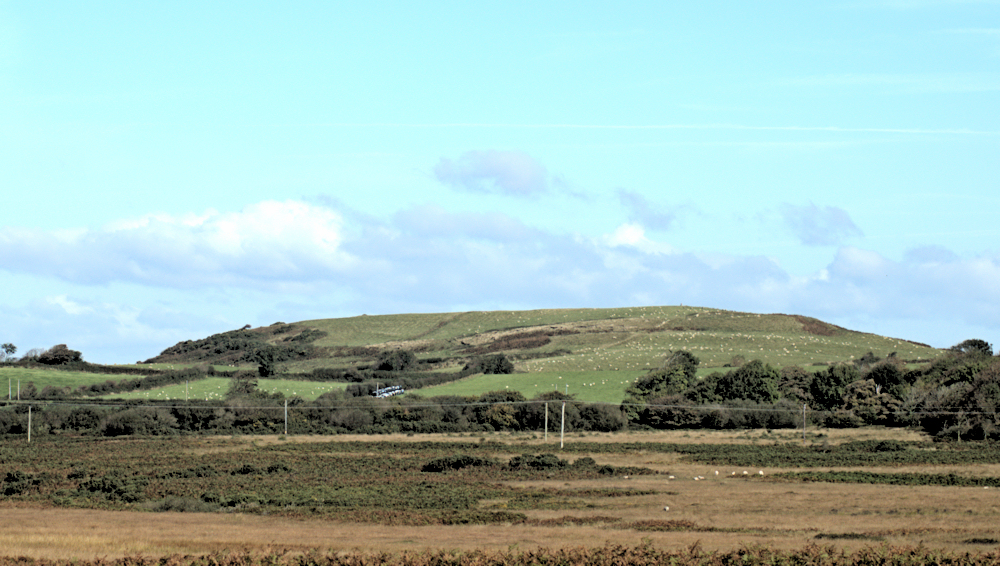 Cil Ifor hillfort (click image to enlarge) |